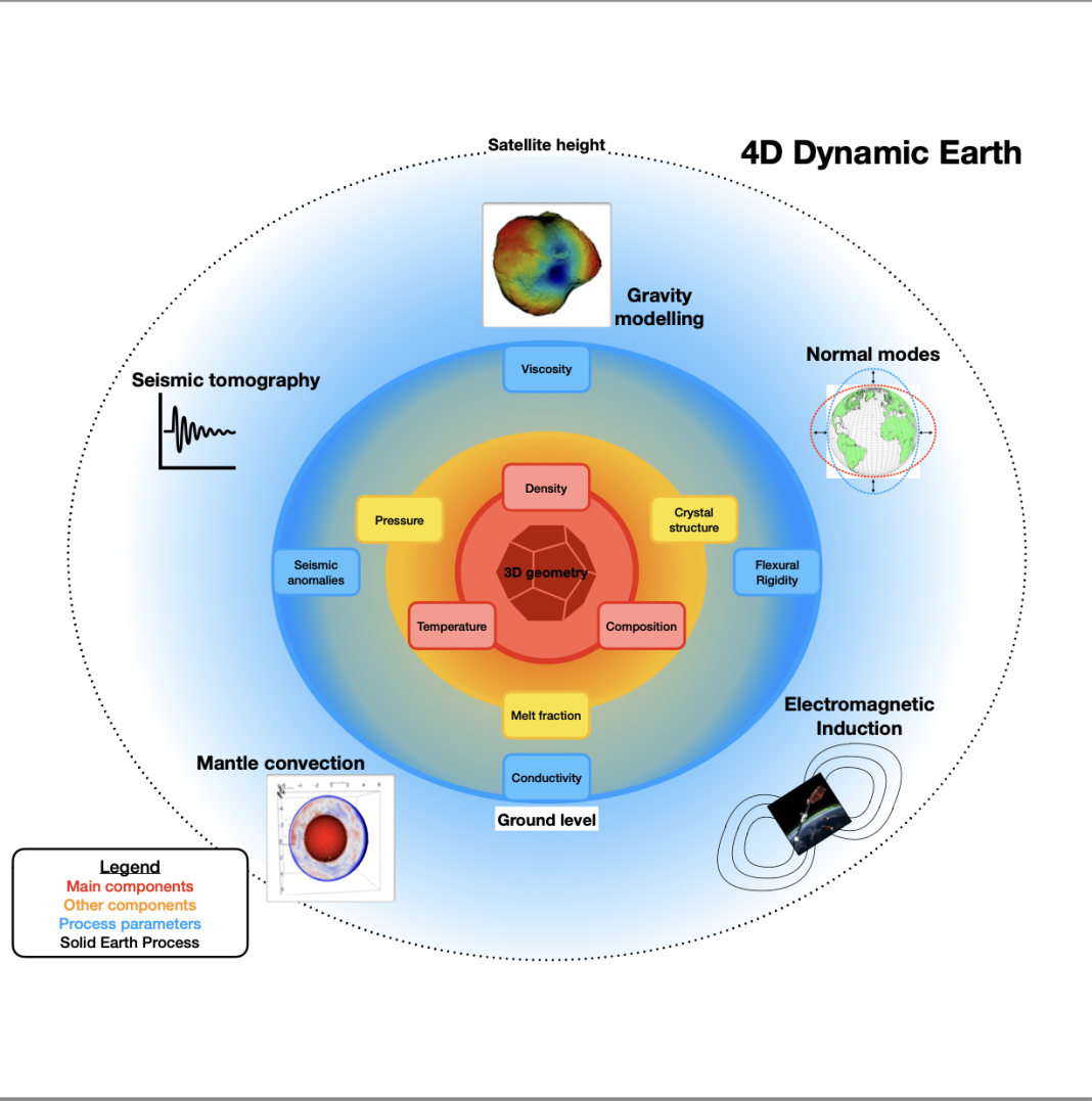
B.C. (Bart) Root, an Assistant Professor at Delft University of Technology, discusses the 4D Dynamic Earth: Phase 1 project, which is enhancing our understanding of the planet’s interior
The Earth’s mantle is a vast layer of hot rock beneath our feet that plays a crucial role in everything from volcanic eruptions to plate tectonics and even long-term climate stability. Understanding the dynamics of this deep, unseen part of our planet remains a significant scientific challenge.
The European Space Agency (ESA) funded the 4D Dynamic Earth: Phase 1 project, which developed a new generation of integrated models that combine multiple data sources to reveal how the mantle is structured, plus adding the “fourth dimension” to our geological understanding of temporal evolution. Understanding the role of the deep Solid Earth in predicting geological hazards, monitoring the long-term carbon cycle, and even planning future resource management strategies is essential.
A new era of integrated Earth modeling
At the heart of this effort is the WINTERC framework, initially developed in an earlier ESA-funded 3D Earth project. This framework has now been extended by including deeper regions of the Earth’s mantle, such as the transition zone and lower mantle. These regions influence large-scale Solid Earth processes but have historically been difficult to model due to limited data resolution and computational complexity.
We have combined millions of seismic observations with satellite gravity data in a consistent thermodynamic framework, that uses validated petrological models to better capture the complex variations in mantle composition, density and structure. These advances enable us to reliably predict deep mantle flow, heat variations, and composition changes on a global scale, thanks to the geochemically consistent approach.
Testing thermodynamic framework with rock samples
To ensure that these models are grounded in reality, the thermodynamic framework was validated using a dataset of over 500 mantle rock samples. These samples are collected from peridotitic mantle material found in nature, revealing the rock composition well below our feet. They serve as benchmarks for testing predictions about how, for example, seismic waves travel through various mantle compositions.
Towards a better view of the deep Earth
One of the project’s most exciting frontiers is the inclusion of normal modes; the Earth’s natural “ringing” motion after large earthquakes. Connecting these observations with the classical seismic tomography would sharpen our understanding of the lower mantle. Furthermore, when combined with gravity data, these techniques help separate velocity anomalies from density anomalies, which is essential to understand the compositional complexity of the mantle.
Simulations have even shown that massive, mantle structures known as LLSVPs (Large Low-Seismic-Velocity Provinces) alter Earth’s magnetic field behaviour by delaying magnetic changes near the core-mantle boundary by several years. Mapping their characteristics is vital to understanding the magnetic field variations we measure on land and in space.
Magnetic clues from space
Beyond seismic and gravity data, the project also tapped into the magnetic field data from ESA’s Swarm satellite mission to explore variations in mantle conductivity. Since conductivity is sensitive to temperature, composition (iron content), and even water abundance in rocks, this data provides a powerful tool for probing Earth’s deep interior.
Our results suggest that Swarm data can already detect 3D conductivity differences in the upper and mid-mantle. With longer data records, this method could help map conductivity even deeper, providing new insights into how water is stored throughout the mantle and how it dictates the flow movement, a factor that influences everything from melting processes to plate movement.
Tackling viscosity and future observations
One of the biggest unknowns in mantle dynamics is the viscosity of mantle rock, a measure of how resistant the rock is to flow. Since our best estimates of this characteristic can vary by several orders of magnitude across different regions and depths, getting it right is essential for predicting dynamic Earth processes. We tested various viscosity profiles based on glacial isostatic adjustment (GIA), tectonic plate movements, and other geodynamic indicators.
Looking ahead, next-generation satellite gravity missions, such as the proposed MAGIC mission, could detect slow, tiny changes in the gravity field caused by mantle mass movement. This would allow us to directly observe deep Earth processes with unprecedented resolution. The promising new dataset would potentially be available within a decade of continuous data collection using newly developed satellite missions.
Societal benefits: Earthquake risk, uplift, and resources
This modeling framework is not just theoretical, it is already being applied to real-world problems. The team studied several regions of high societal interest. The 3D structure of the mantle can significantly influence surface-level hazards and long-term geological stability. In the UK and Ireland, for example, variations in mantle and crust thickness influence seismic activity and ground uplift, which have an impact on future housing construction. 4D Dynamic Earth can support hazard planning and infrastructure resilience.
Developing a digital twin of the Solid Earth
The long-term vision of the project is to create a Digital Twin of the Solid Earth: a real-time, data-integrated model that simulates Earth’s deep processes from core to crust. Such a tool would revolutionise how we forecast geohazards, plan infrastructure, and study the evolution of our planet. This requires continued investment in: satellite observation systems (investing Electromagnetic Induction Mantle convection Legend Main components Other components Process parameters Solid Earth Process Flexural Rigidity in the European Space Agency), high-performance computing facilities for global-scale modeling, and cross- disciplinary collaboration among seismologists, geodynamicists, geochemists, and space agencies.
By bringing together global data and advanced simulations, 4D Dynamic Earth is not only reshaping how we view our planet’s interior, but it is also preparing us to make more informed decisions about the surface we live on.
For more information, please visit: https://4ddynamicearth.tudelft.nl/


