
Per Undén, Senior Scientist, Coordinator at the Swedish Meteorological and Hydrological Instute (SMHI) highlights UERRA – the FP7 pre-operational Copernicus Climate Change Service (C3S) Project…
Weather Forecasting is based on an analysis of the current state of the atmosphere and the surface of land and sea. The forecasts are made with mathematical and physical computer models starting from the analysis. The temperatures, wind, pressure, moisture, cloud contents and other variables are mapped at regular points in space and time. The analysis uses as many observations as possible, but in most places they are not available that close together.
By using the same model of the atmosphere’s evolution as is used for forecasting, a prior estimate, a first guess of the analysis can be obtained. That model forecast has in its turn used earlier analysis based on previous observations and from other places. The process of repeatedly combining such a first guess with observations is called data assimilation.
The analysis procedure is updating the first guess with small corrections. The procedure also uses physical and statistical relationships of the atmosphere when interpreting the observational data. The analyses can in these ways produce values of the atmosphere and the surface away from the observations.
Even though the analyses are made for the purpose of accurate weather forecasting, the mapped variables of the atmosphere have an important value on their own. Many applications and users want to know the best estimate of the atmospheric state at any given time, for assessing past weather events, for statistics of the climate in a location or an area or for running other fine scale models or validating climate models.
Weather Forecasting models and the analysis procedures are improved and enhanced all the time e.g. with increased resolution. The ever increased quality of the resulting analyses makes it difficult to use a long time series over years and decades. Especially for climate monitoring, it is a requirement to have a fixed system for doing the analyses over the years. The old analyses made a long time ago can be greatly improved by employing a more recent operational system, both due to improved methodology and higher resolution. A number of meteorological centres have re-run their old analyses with their most recent system. This is called Reanalysis. See the illustration below.
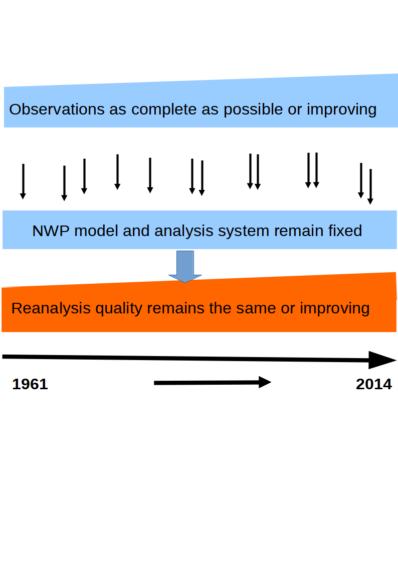
Another important reason for doing this is that more observations, can be made available after the time of the real time analyses. It is both through receiving late-coming data and especially through data rescue of old observational archives often on paper. UERRA has a Data Rescue (and Development) activity and some 8M data have been digitised from several countries in and around Europe and on a sub-daily scale.
Global centres have made a number of generations of reanalyses and there are also a few regional reanalyses covering e.g. North America or Europe or sometimes only a part of Europe.
Now, the current successor project, UERRA, does much more than the earlier European reanalysis (EURO4M). The horizontal resolution is doubled from about 20 to 10 km and there are 4 different reanalyses in parallel, from 5-35-50 years’ time span. Moreover there are 8-20 different ensemble members with slightly different values of the analyses due to uncertainties in the atmosphere, observations and methodology. Both the spread between the different models, (multi-model) data sets and within the ensemble data sets will be used to gauge the uncertainties. These uncertainties will be quantified and derived from independent data sets using other observations or from very high resolution local data sets. The different models and ensembles and the time periods covered are illustrated below.
Data services including visualisation services have been built and adapted to a common UERRA archive. A common set of meteorological parameters from the Met Office, SMHI, University of Bonn and Météo-France from the new UERRA reanalyses are being archived from 2016.
The different reanalysis streams together with ensembles and subsequent data services are prepared to be able to continue and evolve in an operational copernicus service and the results stored and disseminated in the Copernicus Data Store.
Per Undén
Senior Scientist, Coordinator
Swedish Meteorological and Hydrological Instute (SMHI)
Per.Unden@smhi.se
Please note: this is a commercial profile


