Urban areas are prone to climate change impacts. Simultaneously, the world’s population increasingly resides in cities. What needs to be done to protect them?
The Climate Service Center Germany (GERICS) was initiated by the German Federal Government in 2009 as a fundamental part of the German hightech strategy for climate protection. Since June 2014, GERICS has been an independent scientific organizational unit of the HelmholtzZentrum Hereon.
The interdisciplinary team at GERICS develops scientifically based prototype products and services to support decisionmakers in politics, business and public administration in adapting to climate change.
1. Introduction
Urban areas are prone to climate change impacts. Simultaneously, the world’s population increasingly resides in cities. The growing awareness of the interlocking drivers of urban change and vulnerability calls for institutional transformation, and the need to link adaptation action to development efforts demand innovative approaches to connect sciencepolicy and practice. In this light, there is a growing need to equip urban decision-makers with evidencebased climate information tailored to their specific context, to adequately adapt to and prepare for future climate change impacts.
2. Improving climate information for cities
When providing climate information for cities, the uniqueness of urban areas needs to be taken into account. The materials, emissions, and builtup structures in cities result in an urban climate that can locally modify the regional climate as well as the expected climate change signals. One of the wellknown phenomena is the urban heat island (UHI), which describes the higher nighttime temperatures in urban areas compared to the rural surroundings. However, there are also urbanrural contrasts in humidityrelated climate conditions.
The research conducted at GERICS shows that regional climate models offer a useful tool for understanding urbanrural temperature and humidity contrasts under climate change. Especially the added value of the stateoftheart convectionpermitting models to provide the underpinning science to improve the development of knowledgebased climate information for urban regions is evident. For example, GERICS scientists found an urban drying effect in Berlin compared to its surroundings for relative and specific humidity under climate change, respectively, for the urbanrural contrast throughout the 21st century. Furthermore, the research investigates three innovative case studies to understand humidity-related impacts, such as pollen dispersion, influenza survival and spread, and indoor mould growth (Langendijk et al., 2022). An increase in pollen and decreases in influenza and mould are expected under near term climate change impacts, as projected by convectionpermitting models.
To further improve the understanding of the effect of urban areas on the regional climate and on the impact of regional climate change on cities, GERICS collaborates with a large group of international experts within the framework of the WCRP CORDEX flagship pilot study “URBan environments and Regional Climate Change (URBRCC)”.
The threat of anthropogenic climate change is considerably high for the rich and diverse cultural heritage in Germany. However, there is still a lack of reliable data on how the climate will change in future at the cultural heritage sites in different regions and to which extent the future climate will influence heritage typologies and materials. To address these important scientific questions, the KERES project has been launched by the German Federal Ministry of Education and Research.
The aim of KERES is to use the data of high resolution regional climate models to assess the risk of damage to historic buildings and gardens and to develop sustainable preventive and emergency measures for their preservation.
Climate Service Center Germany collaborates with four Fraunhofer Institutes from the Cultural Heritage Research Alliance (Fraunhofer Institute for Silicate Research ISC – Project Lead, Fraunhofer Institute for Building Physics IBP, Fraunhofer Center for International Management and Knowledge Economy IMW, Fraunhofer Institute for Optronics, Systems Engineering and Image Exploitation IOSB) and the Prussian Palaces and Gardens Foundation Berlin Brandenburg.
Another stateoftheart tool that provides very detailed climate information at the local level is highresolution obstacleresolving urban climate models such as PALM4U and MITRAS. Within the framework of the HelmholtzInstitute for Climate Service Science (HICSS), scientists from GERICS and the Universität Hamburg are enhancing the capability of such models to meet special requirements of city planners. For instance, adaptation measures specifically developed for a changed summer climate can have different effects on urban climate in winter, especially with the presence of snow. The HICSS project WINTER, therefore, aims to quantify climate change impacts on the winter climate of Hamburg in detail.
In order to assess changes in winter within the urban setting, the obstacleresolving model MITRAS is extended to allow for rainwater to settle on roofs and walls (Figure. 1), which leads to a more realistic representation of the winter urban climate in Hamburg. With the extended model, sensitivity studies to assess the impact of different wind speeds, wind directions, rain amounts and topographies on precipitation are carried out for a realistic urban setting around Hamburg City Hall for a winter day. Analysing the results revealed that varying the meteorological situation causes rather different heterogeneous patterns of the rain amount on the ground even in this relatively small area. This underlines that for a realistic representation of a rain event (hindcast), it is essential to know the meteorological situation as well as the obstacle structures (Ferner et al., 2022).
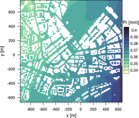
Hamburg City Hall for a winter day. Analysing the results revealed that varying the meteorological situation causes rather different heterogeneous patterns of the rain amount on the ground even in this relatively small area. This underlines that for a realistic representation of a rain event (hindcast), it is essential to know the meteorological situation as well as the obstacle structures (Ferner et al., 2022).
- Langendijk, G.S., Rechid, D. and Jacob, D. (2019) Urban Areas and Urban–Rural Contrasts under Climate Change: What Does the EUROCORDEX Ensemble Tell Us?— Investigating Near Surface Humidity in Berlin and Its Surroundings. Atmosphere. 10, 730.
- Langendijk, G. S., Rechid, D., Sieck, K., & Jacob, D. (2021). Added value of convectionpermitting simulations for understanding future urban humidity extremes: Case studies for Berlin. Weather and Climate Extremes, 100367.
- Langendijk, G. S., Rechid, D., & Jacob, D. (2022). Improved models, improved information? Exploring how climate change impacts pollen, influenza, and mold in Berlin and its surroundings. Urban Climate, 43, 101159.
3. Codevelopment of new tools
Extreme climate events such as heat waves or extreme precipitation and other slowonset events such as sealevel rise present key challenges to urban areas. For example, cities on the coast remain most vulnerable to hazards resulting from climate change, like sealevel rise, intensified storm surges and coastal flooding, while pluvial flooding is projected to increase in frequency and intensity of heavy rainfall events. Different modelling techniques and the application of new technologies, such as machine learning, can help us estimate the impacts of these events and to plan for sound adaptation actions; for example, using ecosystem services to reduce floods or the effects of high temperatures.
Modelling Urban Dynamics Affected by Climate Change for Coastal Spatial Planning and Management (MUCCCS)
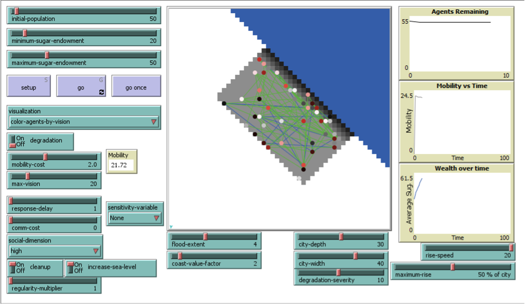
Adaptation planning strategies for dealing with such hazards include coastal protection measures, including the construction of embankments but may also extend to relocation of urban areas inland in extreme cases. The MUCCCS (Modelling urban dynamics affected by climate change for coastal spatial planning and management) project aims to support the creation of climate services for planning such coastal adaptation strategies, by developing a family of models that can simulate the complex dynamics of the coastal city. The project explores modelling urban dynamics through multiple social simulation approaches, primarily employing agentbased modelling, to create a comprehensive and interdisciplinary toolset with which possible human responses under increasing risk can be explored (Figure. 2).
Machine Learning
Climate extremes such as high temperatures have an impact on health outcomes, but coincide with several other environmental and demographic factors that are all dynamic over time. To solve this, we applied a machine learning approach where we used five different algorithms to calculate the temporal variations of myocardial infarction occurrence, using information from the KORA dataset in Augsburg, Germany (Marien et al., 2022). The results show that we can very well estimate the interannual variability of infarction occurrence and that air quality, air temperature, and demographic changes are the most important factor affecting its occurrence. These models can be used to estimate future changes based on projection of climatic and other variables, including aging of the population, increases or reductions in air pollution, and further warming leading to more temperature and humidity extremes. Finally, adaptation measures such as greening of the urban environment can potentially also be evaluated with this approach.
Reference:
-
- Marien, L., Valizadeh, M., Zu Castell, W., Nam, C., Rechid, D., Schneider, A., Meisinger, C., Linseisen, J., Wolf, K. & Bouwer, L.M. (2022). Machine learning models to predict myocardial infarctions from past climatic and environmental conditions. Natural Hazards and Earth System Sciences, 22(9), 30153039
Projecting the performance of urban flood regulating ecosystem services under future climate conditions
Pluvial flooding is projected to increase in frequency and intensity of heavy rainfall events. Ecosystem Services provided by nature can help to reduce floods. This study focuses on the analysis of flood regulating ecosystem services in urban areas for heavy rainfall events (Figure 3).
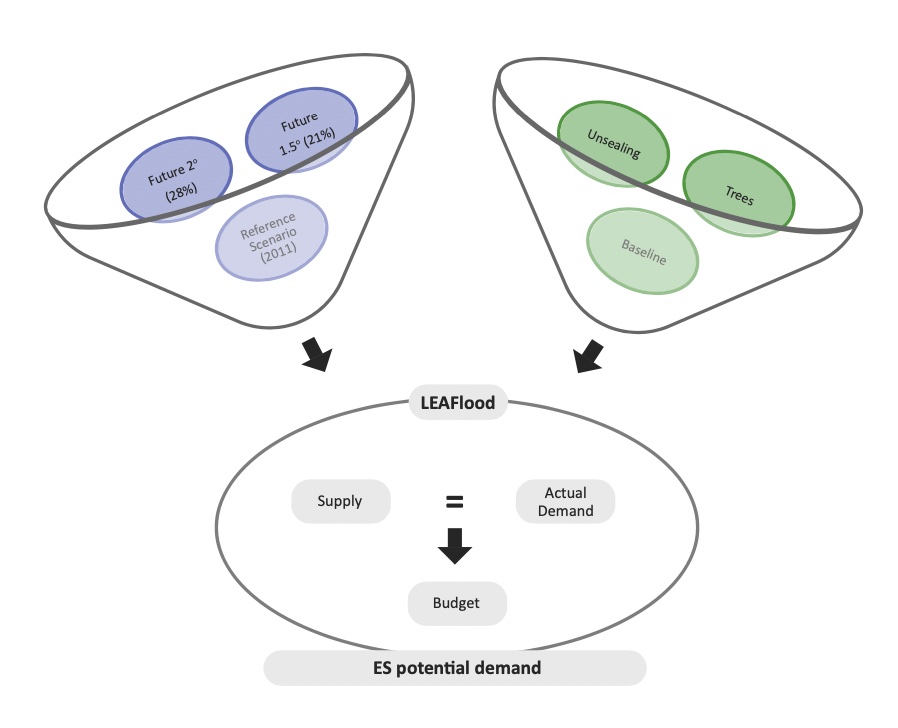
For this purpose, the hydrological model LEAFlood was set up based on the Catchment Modelling Framework to ensure an adequate representation of single urban structure elements and to consider important vegetation-related flood regulating processes in urban areas such as interception. In a second step, a flood regulating ecosystem services analysis of supply (water storage on canopies and soil) and demand (need for flood protection by different sectors) was conducted in a neighbourhood of the city of Rostock to identify mismatches of supply and demand. The outputs of the LEAFlood model served as indicators for this analysis. This was further developed to estimate the flood regulating ecosystem services change for more intense rainfall events due to changing climate conditions compared to a reference scenario of 2011 and the benefits of natural adaptation measures.
4. Codevelopment of climate services for cities
With the help of the improved climate information and the new scientific tools, climate services can be codeveloped that are tailored towards cities. An excellent tool to support adaptation action and to integrate regional climate information into the existing environmental and regulatory frameworks is the GERICS adaptation toolkit for cities (German product name: GERICSStadtbaukasten, Figure 4). The idea behind it is to have numerous independent but easytoconnect and easyto use modules, which address different important aspects – e.g. the vulnerability against urban, river or groundwater flooding or the climate proofing of compensation measures – relevant to represent and to understand the respective systems such as the climate resilience of the critical infrastructure from administration as well as other stakeholder perspectives. Depending on the practical challenges and needs, the relevant modules can be selected and combined individually.
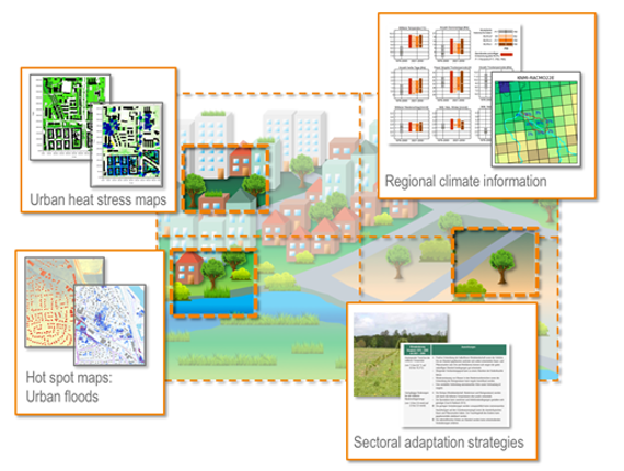
This concept was – and currently is – tested in different types of cities, ranging from small municipalities to state capitals. The locations are all over Germany including cities at the coast as well as densely populated areas inland. The main goal of our activities in all cases is the support of adaptation processes. This includes techniques for a systematic assessment of current and future opportunities and vulnerabilities due to climate change impacts.
But adaptation is more than creating hot spot maps or developing adaptation strategies. For successful adaptation, communication is key. Therefore, only through the codevelopment and codesign with local decisionmakers and local experts (such as urban planners, water and energy suppliers, etc.), the inclusion of local knowledge can be ensured.
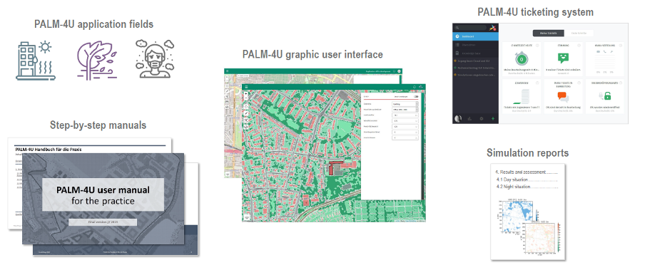
PALM4U allows highresolution simulation of various urban climate studies from entire city scale down to individual building blocks. Within the ProPolis project, GERICS scientists in close cooperation with practice partners help to secure the practical implementation of PALM4U through designing and testing fields of application for this model that include thermal comfort, cold air balance, local wind comfort as well as dispersion of pollutants (Figure 5). In addition, they are also involved in the development of the fit for purpose graphic user interface (GUI) that will be available as an open source software after the end of the project.
Further products with contribution of GERICS such as user manuals, training programs, a support system and an online community forum will enable practitioners to apply the model for their individual planning questions and adaptation measures as well as to exchange their experiences with other users.
All the information about PALM4U model, its application and allround services will be brought together in a virtual platform PALM4U Service Hub that is currently being developed as a part of a continuation strategy. The future governance structure involves not only model developers but also the growing practice community that will bring their needs into further model development and thus ensure its practicability and userfriendliness in the long term.
5. Overcoming obstacles in the application of climate services
Although climate information may be considered useful for its perceived support to contextualise climate change as a local policy issue, usefulness is not an attribute that guarantees climate information is usable to support adaptation action.
In order to develop useful and usable climate services for adaptation to climate change impacts in urban areas, stakeholders need to be involved in the codesign of service provision. However, urban decisionmaking is not merely based on available and usable knowledge. Instead, it is embedded in a complex multigovernance system, influenced by diverse and conflicting policies, regulations, interests, and values that give meaning to facts.
Exploring the use of climate information in practice
This research aimed to bridge the usefulness usability divide by presenting a novel conceptual approach to explain the use of climate information as social practice. Drawing on theories of practice and empirical evidence gathered in three city administrations, the use of climate information is explained as social phenomena unfolding in a working context through a network of social practices.
The article shows that the use of climate information is mediated by how people interact, learn, assess work and become accountable for how they work. The research shows that the use of climate information transpires in four social dimensions: a legitimacy dimension, where usability requires deliberate legitimation action; an outcome dimension, where usability depends on working practices; a consequential dimension, whereby the use of climate information provokes changes in working practices; and a processual dimension, which indicates that the use of climate information coevolves with working practices. Findings emerging from this research are being used to inform about:
- The identification of climateinformation users’ needs;
- The expost assessment of the impact of climate information and climate services on working practices and institutions;
- The design of practiceoriented policy intervention to increase the use of climate information.
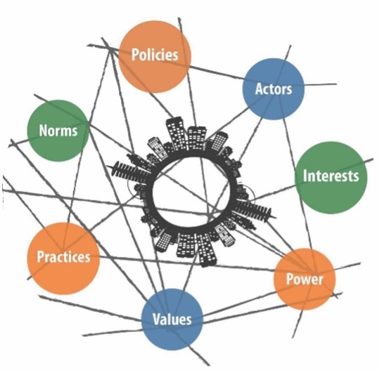
iSPECS: Institutional and sociocultural preconditions for the effective codevelopment of localized actionable climate services – a comparison of Hamburg and São Paulo
iSPECS aimed to understand better the urban decisionmaking environment with which climate services are expected to interplay with. Comparing the cities of Hamburg (Germany) and São Paulo (Brazil), it investigated the institutional and sociocultural aspects that shape the co production and use of climate information in urban decisionmaking (Figure 6). Based on interviews and a digital workshop with actors from both cities, as well as a document and literature review, we found that missing information or expertise was less of a challenge in both cases. Instead, the uncoordinated use of climate information and the challenge to translate this information into just solutions, the structural lack of resources to engage with climate information beyond obligatory work procedures, as well as the consideration of other urban problems like social inequalities or the need for housing hampers that climate information leads to action.
6. Beyond climate adaptation
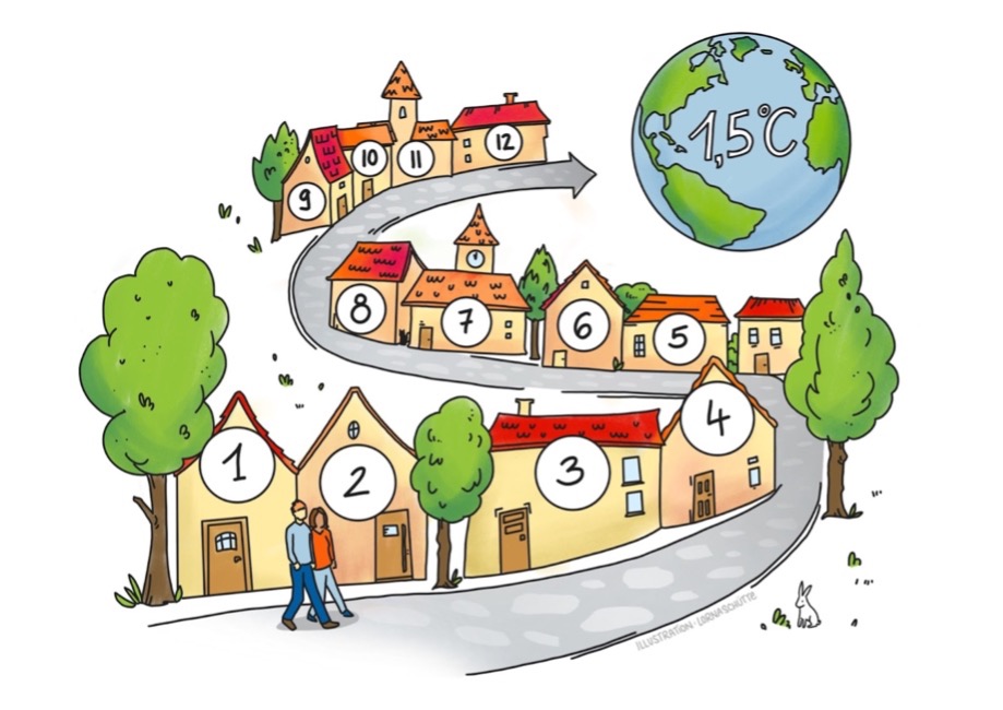
On the way to climate neutrality, the case study “Climateneutral City – dialogues with citizens and stakeholders” focused on various related opportunities and challenges in the urban environment. Particular emphasis was placed on the development of new approaches in interaction with the public in the city of Karlsruhe, being one of the German pioneering cities with the goal of climate neutrality. In addition to the activities specific to Karlsruhe, the case study also included the development of further demand oriented products with overriding importance and relevance to support cities on their way to climate neutrality. In particular, advances in digital communication achieved during the pandemic period were used to develop new and pandemicresilient formats for citizen and stakeholder dialogues – also to be used in a post pandemic period. In this context, monitoring concepts of activities related to the transformation processes involving scientists and the public were initiated within the case study. A central element of these concepts is the transparent publication of data in public space to fulfil the mostmentioned success criteria “transparency”. The main products that were developed are “Cities on the way to climate neutrality examples and supporting initiatives”, “Municipal climate emergency a brief overview from a legal perspective”, “Climate change mitigation and adaptation to the impacts of climate change synergies and conflicts in the context of municipal concepts and strategies” and “12 steps to municipal climate neutrality” (Figure 7).