
LANDSUPPORT aims to help support sustainable agriculture and forestry, and evaluate land use, with the development of a GeoSpatial Decision Support System
 LANDSUPPORT stands for “Development of Integrated Web-Based Land Decision Support System Aiming Towards the Implementation of Policies for Agriculture and Environment”.
This project is funded by the European Union’s Horizon 2020 Framework Programme for Research and Innovation (H2020-RUR-2017-2) under grant agreement No. 774234. The project started on 1st May 2018, and it will last for 42 months.
LANDSUPPORT is coordinated by CRISP – the Inter-departmental Research Center on Earth Critical Zone in Support of Landscape and Agri-environmental management – which is part of the University of Naples Federico II. Project involves 19 partners from 10 countries both in and outside the EU (Italy, Austria, Hungary, Germany, Spain, France, Belgium, Slovenia, Malaysia and Tunisia).
Many European directives and policies indeed aim at reconciling agriculture and environment, preserving natural resources and adapting to climate change at the same time. However, full implementation of these directives and policies is still challenging. Moreover, several web GIS and DSS have been developed in the last decades to provide a support to environmental policy making, agriculture and land use management. However, current approaches are often too simple and available DSS are scale-specific and monodisciplinary, thus hardly adaptable to different contexts and territorial scales.
LANDSUPPORT aims at making the difference in current practices by developing an integrated modelling approach supplying multiple applications and benefits to support sustainable management of land resources and sustainable agriculture and forestry practices.
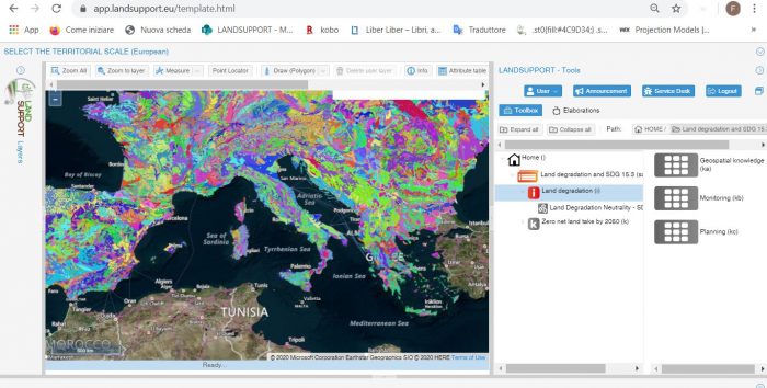
LANDSUPPORT project aims at developing a web-based, open-access GeoSpatial Decision Support System (S-DSS) ), which shall provide a powerful set of tools devoted to:
- support sustainable agriculture and forestry;
- evaluate trade-off between land uses;
- contribute to the development and implementation of about 20 European land use and also selected 2030 UN Sustainable Development Goals.
To achieve this, LANDSUPPORT is developing more than 100 operational, trans-disciplinary S-DSS tools, based on a smart Geospatial CyberInfrastructure (GCI), to create a set of innovative scientific, technical and land policy-oriented specific objectives.
This will be possible by the integration of already existing databases (interoperability) at different scales with the development of high performance modelling engines simulating agriculture & forestry (e.g.crop growth), land degradation and environmental issues (e.g. fate of pollutants, ecosystem services). All the above, including their validation by remote sensed data, will be ensured by a technology at the state of art for the developing environment (i.e.COMPSs), high- performing computing (e.g.GPU) and massive raster data management (e.g.RASDAMAN).
Project activities are carried out on different geographical and governance scales, from the European level to the national and regional/ local scale –in Italy, Hungary and Austria – with two additional pilot sites in Tunisia and Malaysia. This allows for testing LANDSUPPORT tools in very different physical, socio-economic and cultural settings.
LANDSUPPORT S-DSS platform beta version and its tools are already available! Let’s discover and try it on https://www.landsupport.eu/dss-platform/ and for more information about LANDSUPPORT project please visit www.landsupport.eu .


