
Peter Krzystek, Professor for Photogrammetry and Remote Sensing at Munich University of Applied Sciences tells about new investigations into the 3D mapping of forests
Forests cover approximately 31% of the earth’s land surface and play an important role as ecosystems, carbon storage and renewable energy resources. For the investigation of adaptation processes and reactions of forest ecosystems to climate change, a permanent monitoring and recording of different forest structure parameters (e.g. tree species distribution, wood stock, dead wood distribution and renewable regeneration) in selected observation areas with high accuracy is required.
In particular, dead trees are of mandatory significance. For instance, around one-third of all animals and plants living in forests rely on dead wood. Furthermore, 11% of all greenhouse gas emissions are sequestered by the world’s forests, while 14% of total carbon stocks in forests are contained within dead wood.
Knowledge of dead wood and forest structures in general, is fundamental to understanding, protecting and preserving the biodiversity of our forests. As well as gaining a good understanding of ecological health, comprehensive environmental monitoring of our forests and the structures within, are also important in disaster management. From monitoring entire forests in the case of wildfires to tracking the spread of disease in single and dead trees – gaining accurate information on the status and distribution of these structures over various time scales are vital. This information is used by forest managers, researchers and governmental and inter-governmental institutions.
Modern remote sensing sensors offer completely new possibilities for an extensive and detailed 3D capture of tree populations, making it possible to map at very large-scale. In particular, LiDAR is today an established technique for fast and highly accurate 3D scanning from the aircraft, helicopter or drone where pulses of visible or near-infrared laser light at a particular wavelength are used to create 3D images. These 3D images are typically made up of a high density of data points, known as ‘point clouds’. The new full waveform technology, which reconstructs the complete path of the laser beam through the vegetation, makes it possible to map the forest structures in 3D more precisely. Moreover, digital aerial cameras enable a detailed reconstruction of the forest surface and provide – if fused with LiDAR data – extra spectral information in the infrared range for a characterisation of the tree species. All in all, these new technologies are ideally suited for the automatic and cost-effective collection and characterisation of forest stands.
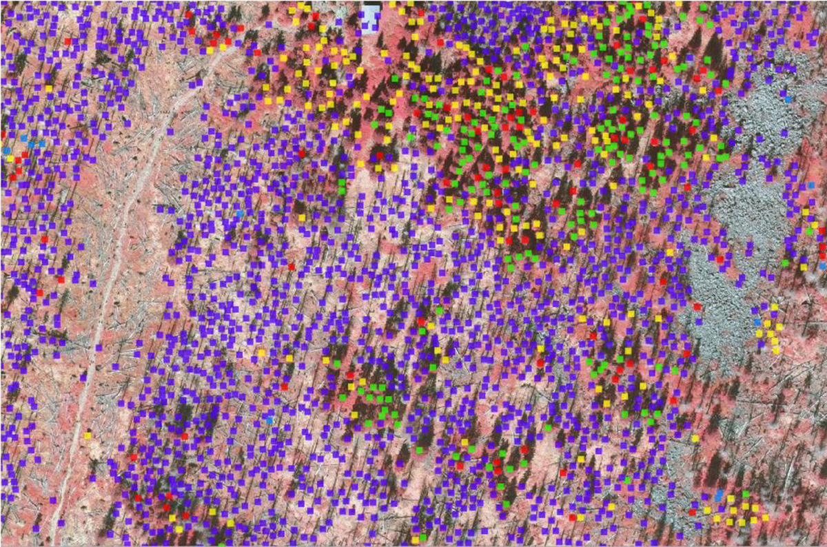
IMAGE CREDIT: Image: © National Park Bavarian Forest
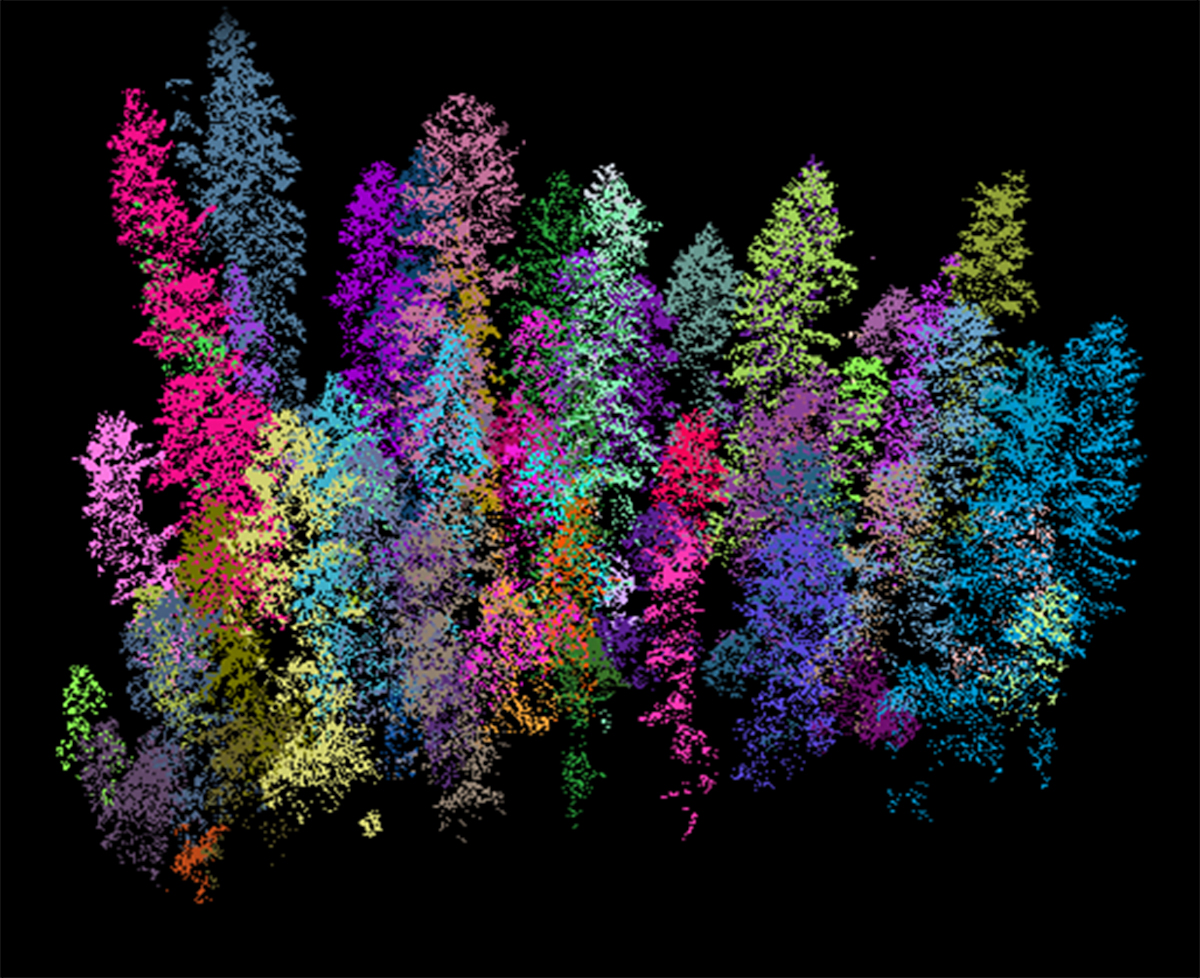
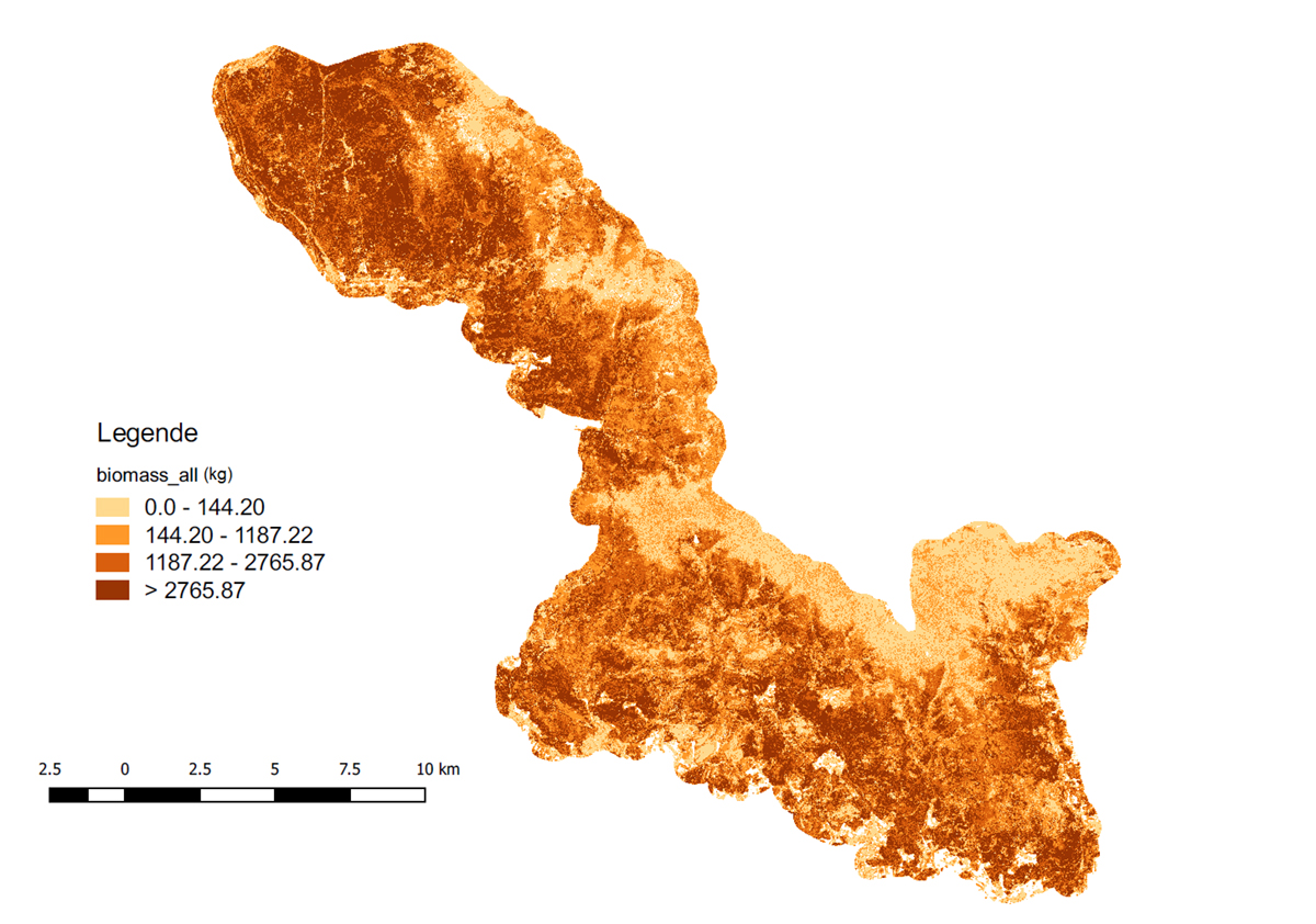
We have been focusing our recent research at the Munich University of Applied Sciences on developing innovative methods of the 3D mapping of trees, by applying advanced computer techniques such as machine learning and computer vision. We were extremely successful in demonstrating that forest areas can be completely and automatically processed with LiDAR to produce 3D maps of individual trees, even at very large scales. The results of our methods enable an area-wide 3D vegetation mapping and provide precise information about the percentage of tree species, stock of wood, wood growth, wood harvest in forests and biomass.
The key method is a new approach for single tree detection from the LiDAR point clouds, which turned out as the breakthrough idea in 3D forest mapping. The newly patented technique approach takes advantage of a special segmentation technique adapted from image analysis. This technique subdivides the forest area into voxels or supervoxels, labels every point in the point cloud and groups these points into disjoint tree segments. The new full waveform LiDAR data helps to significantly improve the detection rate. Based on that technique, coniferous and deciduous trees can be classified with excellent accuracy. As well as the classification of multiple tree species could be significantly improved using multispectral data from LiDAR and aerial imagery.
The extension of this technique led to methods for detecting fallen and standing dead trees. In training the computers to recognise fallen trees, we observed that there must be a minimum number of data points per tree – otherwise, the computer can’t see the tree. Standing dead trees – either without or with crown – can be identified with an excellent accuracy of around 90%.
Mapping is critical for forest inventory, conservation and planning and LiDAR technology offers researchers the opportunity to gain much more data in a short space of time. Furthermore, the use of LiDAR is increasing, and the cost is declining. LiDAR sensors are becoming more powerful, allowing even more data points to be obtained at several wavelengths.
Meanwhile, we are able to process huge datasets fully automatically to generate a 3D map of single trees, tree species and dead trees. Follow-up products are, for instance, maps for biomass or CO2 stock in a forest area. Since it is expected that new 3D measuring techniques will generate more 3D details of forest objects, existing methods need to be extended to take advantage of the higher point density.
Please note: this is a commercial profile
Prof Dr-Ing Peter Krzystek

and Remote Sensing at Munich University of Applied Sciences
Professor for Photogrammetry and Remote Sensing
Department of Geoinformatics
Munich University of Applied Sciences
Tel: +49 (0)89 1265 2617


