
Gwo-Shyh Song from Global Aqua Survey, with Hsiu-Wen Huang from National Taiwan University, walk us through the application of the marine magnetic survey
The marine magnetic survey is broadly applied to detect ferrous material on the seafloor. After processing, the measured value can be transformed into a magnetic anomaly map; the researcher can locate the ferrous target through analysing magnetic features generated by the ferrous target. Locating electric cables on the seafloor, detecting an underwater artificial target, searching the ship wreckage, studying magnetic contamination and archaeological research are examples of marine magnetic survey applications.
In the past, we used the G880 cesium optical pumping magnetometer to measure the total magnetic field. To avoid the influence of magnetic disturb, the distance between the survey ship and magnetometer sensor remained at three to five times distance compared with the length of the vessel. The nearby Center Weather Bureau magnetic observatory stations were chosen for magnetic ground reference stations.
Different directions of geomagnetism and various shape of ferrous targets change magnetic anomaly features. The most classical magnetic features are dipole mode and pipeline mode. In the studies, two marine magnetic survey cases are displayed as two distinct magnetic features, respectively.
Magnetic anomaly showing the location of seafloor pipeline. The result of the electric cable laid between Liuqiu Island and Taiwan survey shows us dipole magnetic features, and the magnetic anomalies are quite obvious. After data processing, the gridded magnetic map present shows us that the magnetism cables generated are similar to what a linear magnet does. In addition, the direction of the magnetism is alongside the cables. Due to the giant volume involved, the cables are highly magnetized, indeed, the maximum of magnetic anomalies even reached 60 nT. The predicted location of cables is close to the actual ones.
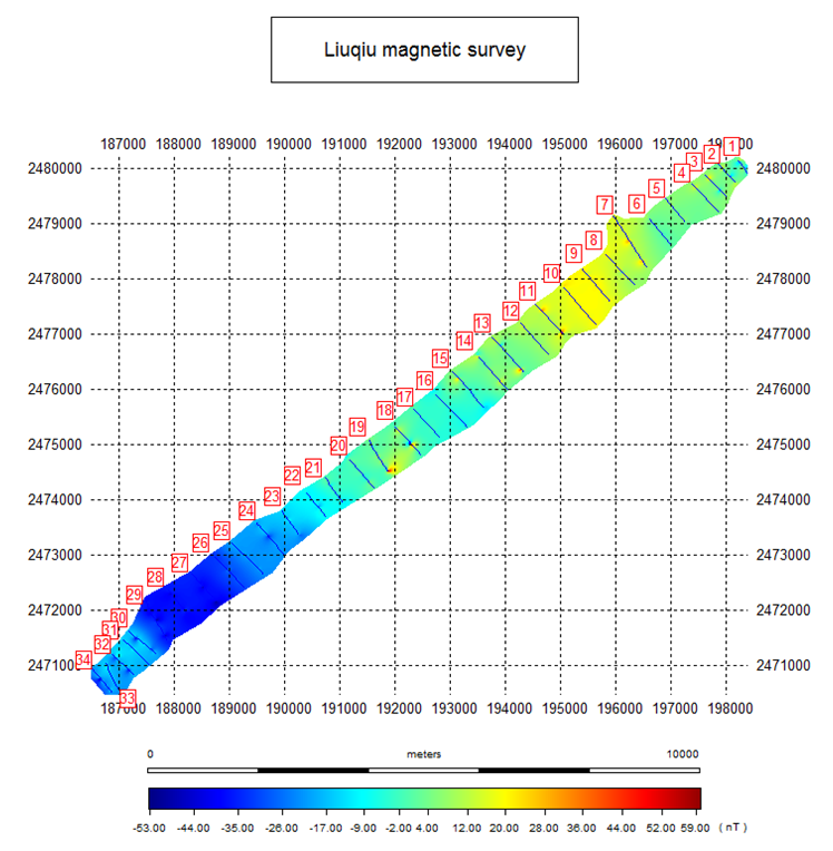
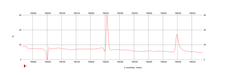
33 transect lines were surveyed in the direction perpendicular to the spread of two cables; magnetic anomalies profile (number 8) crossing cables are shown in the below diagram that indicates anomaly peaks appearance when crossing the cable positions.
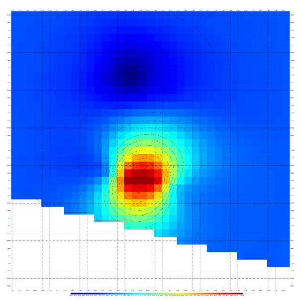
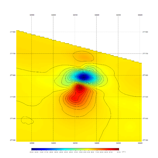
The result of the Longmen offshore (the cooling water inlet of a nuclear power plant) magnetic survey presents a dipole anomaly feature. The gridded magnetic map points out that there are two magnetic anomalies in the survey area; one is in the North-Eastern area; the other is in the West–Southern area.
In the same geo-magnetism field, these two values and directions of anomalies are different. The research concludes that the fact is highly relevant to the depth and heading of the target. The wavelength anomalies is a function of the distances between targets and magnetometer, and the heading of the magnetic source could change the direction of its anomalies. Therefore, the researcher could interpret the depth and heading of the source by studying the magnetic field above it. The side scan image in the same survey area has indicated the accuracy of the interpretation of the magnetic survey.
The marine survey usually comprises multiple measuring methods, so the integration between different kinds of information is important. For instance, combined with a side-scan image, the magnetic survey can pick out ferrous targets of interest, and present the heading, depth, and roughly measuring the weight of ferrous material by studying the magnetic anomalies.
Therefore, the marine magnetic survey is usually applied in the maritime and underwater cultural heritage investigation widely and presents convincing results in detecting and locating the ferrous target. To ensure accuracy, controlling magnetic noise, adjusting the magnetometer correctly and enhancing the location system, like USBL and RTK, are necessary for the marine magnetic survey.
Please note: This is a commercial profile


