
Fabio Terribile discusses the potential of LANDSUPPORT, a Horizon 2020 project showing a way to better manage our landscape and better implement European Union land policies
Let’s start from basics, we have several nice policies in the Europe Union, simultaneously aiming to reconcile agriculture and environment. However, we all know that the full implementation of these directives, communications and regulations is still difficult. Similar challenges are faced when analysing progress in the 17 SDG of the 2030 UN Agenda.
On the other hand, it is self-evident that we are also experiencing an extensive acceleration of land degradation processes due to increasing pressures of urbanisation, agricultural and livestock production, deforestation, and climate change.
Within this framework, we believe that current fragmentation over the same landscapes, between (i) the many policy domains (e.g. agriculture, water, spatial planning), (ii) the many multilevel public authorities (DG-EU, DG-nations, DG-regions, DG-municipalities) applying policies (sometimes conflicting), (iii) the scattered knowledge base (e.g. non-interacting databases), does not help efficient policy implementation and fight against land degradation.
What does LANDSUPPORT propose?
We believe that today if we were able to enhance the connection between currently available large databases, modelling and IT technologies, we could create the missing element: truly integrated geospatial knowledge that could be freely assessed by anybody (end-user, stakeholder, policy maker) to receive support in decision making for sustainable land planning or management, so reconciling agriculture and environment protection and eventually better implementing many of our land policies.
What is LANDSUPPORT?
LANDSUPPORT is developing a completely free, web-based, open-access GeoSpatial Decision Support System (S-DSS) devoted to agriculture, environment and supporting the implementation of about 20 EU policies. Project activities are carried out – by 19 partners (have look to them clicking here) from 10 different countries – on different geographical and governance scales, from the European level to the national and regional/local levels, in Italy, Hungary and Austria, with an additional pilot site in Tunisia.
How does it work?
To achieve its aims, LANDSUPPORT is developing 15 operational, trans-disciplinary S-DSS tools, based on a smart Geospatial CyberInfrastructure (GCI), to (i) support sustainable agriculture and/or forestry, (ii) spatial planning and (iii) selected land policies for both EU and UN agendas (e.g. LDN). These objectives are possible thanks to the integration of already existing multiscale databases (interoperability), datacubes and HPC modelling that simulate agriculture & forestry (e.g. crop growth), land degradation and environmental issues (e.g. fate of pollutants, ecosystem services). This combination of features enables us to address large areas keeping fine details simultaneously, thus enabling actions at the very local scale.
LANDSUPPORT is still in the development phase; What are the first results?
Our results regarding agriculture are still under development. So far, we have developed an innovative operational tool for use in addressing Land Take in the EU. The Land Take tool moves towards Zero Net Land Take by 2050 (7th EAP of EU) and allows users to perform analyses of land consumption due to recent urban expansion, and urban and spatial planning choices for the entire European territory, while maintaining a 20 m resolution (HRL Copernicus). In addition to quantifying the loss of ecosystem services, the tool allows for analysis based on a “what if” logic, simulating reality to guide urban planning choices towards better environmental sustainability. The tool is composed of several features dealing with Geospatial knowledge, evaluate and quantify land take process over time, quantify the impact of new urbanisation on ecosystem services, and estimate and map landscape metrics for planning purposes.
How is it used?
By freely navigating www.landsupport.eu, the user can select any area of interest from EU: a specific municipality, province or region, or simply by drawing an area with a mouse.
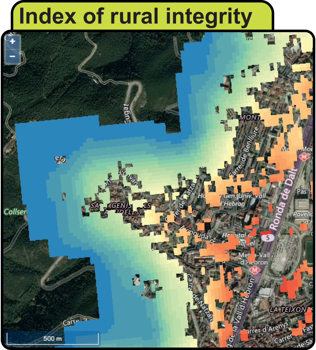
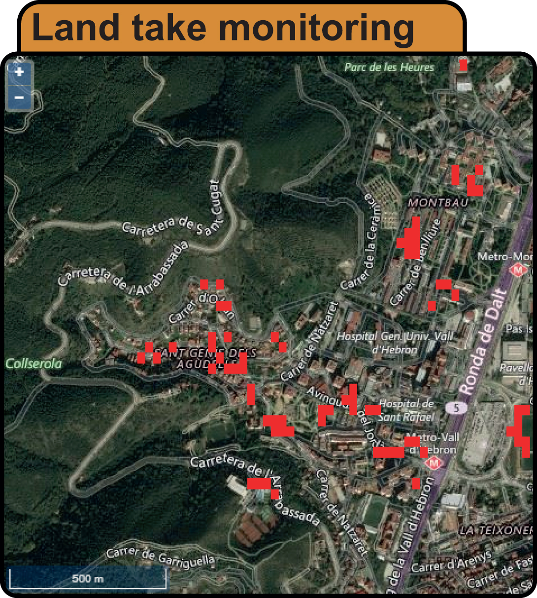
The Land Take tool answers some questions: what is land consumption like in my town? To what degree is a given rural area intact at each point? How would a new urban settlement or of a green corridor affect ecosystems services?
The land take tool, for example, allows users to quantify and locate soil sealing between different years (red areas in figure). The Fragmentation tool, for example, allows users to obtain a raster layer, to each pixel of which a fragmentation value, influenced by the radius value, is assigned. Or by selecting the New Green Corridor tool, the user can draw any area (even choosing % of coverage) for a new green corridor. The result will be a report containing information on the area of interest and the potential gain for ecosystem services and soil organic carbon.
What about land degradation?
The aim of Sustainable Development Goal (SDG) 15.3 is to achieve a land degradation-neutral (LDN) world: Our LDN tool (still under development) enable estimation at any EU administrative level of the trends in land degradation. The methodology uses 3 sub-indicators: vegetation productivity, land cover, soil organic carbon.
What about the future?
Despite being a perfectly functional system that is open to all, the platform is a product of on-going research. There is still much to do beyond the project itself, but Landsupport already shows that a new path for a more sustainable and shared management of our territories is possible. Let’s give it a try!
Please note: This is a commercial profile


