
Professor Robert Aiken, Research Crop Scientist at the Northwest Research – Extension Center and Dr. Ramesh Dhungel, Research Associate at Kansas State University both explain why water is required for plant growth, the foundation of the global food supply and ecosystem services
Water is required for plant growth – the foundation of global food supply as well as ecosystem services. Hence, the linkage of food security and water security.
Most climate change impacts are expected to affect the water sector (IPCC, 2014). These impacts include altered precipitation patterns, reduced availability of freshwater, and reduced water quality. Climate change impacts will likely exacerbate competition for water among agriculture, industry, ecosystems and settlements (MacAlister and Subramanyam, 2018).
Reliable crop water metrics provide computational tools that are particularly suited to the agricultural landscape. Robust survey tools utilise satellite imagery to detect trouble spots, such as drought monitoring services. However, satellite imagery is frequently obscured by factors such as cloud cover, limiting application to water management.
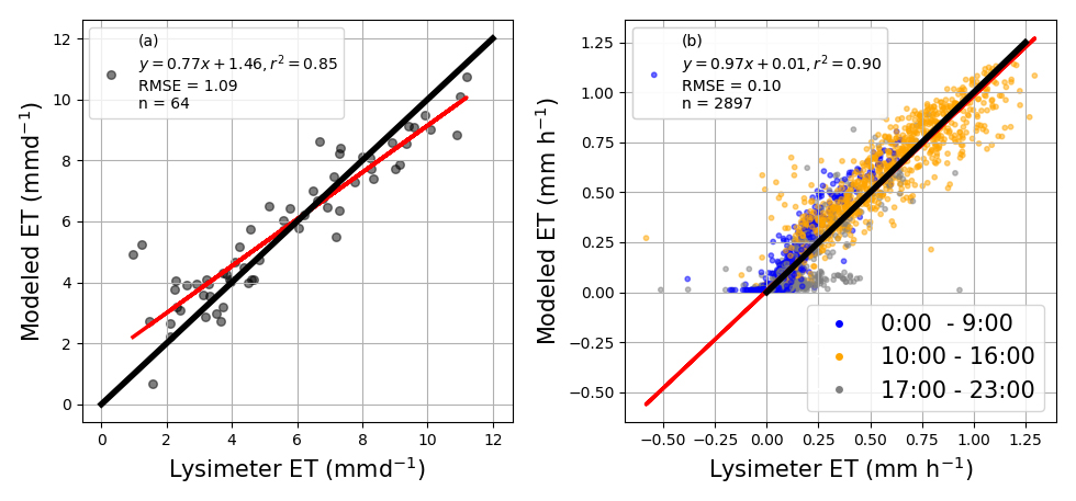
Recent advances in computational tools support use of physically-based energy balance modules to reliably calculate crop evapotranspiration (ET) at landscape and regional scales (Dhungel, et al., 2016). The Backward-Averaged Iterative Two-Source Surface temperature and energy balance Solution (BAITSSS) is a physically-based ET model capable of point scale and landscape simulation of soil water using a vegetative canopy, soils and weather data. Field comparisons with precise field measurements demonstrate the validity of this modeling approach (Figure 1, Dhungel et al., in review).
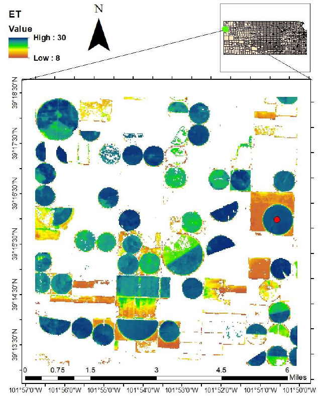
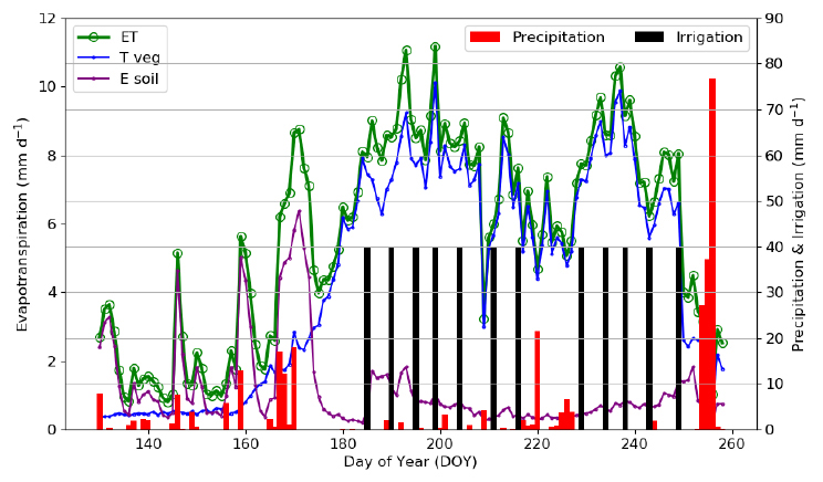
Application to water management is illustrated for a groundwater management district in northwest Kansas, USA. With an improved algorithm, ET was calculated for a township in western Kansas (Figure 2), a region of substantial groundwater depletion. Figure 3 shows water balance components for a particular sampled pixel.
Comprehensive ET analysis provide water metrics for crop systems ranging from dryland to full irrigation. These information services support initiatives such as Local Enhanced Management Areas in Kansas, which operate multi-year water management plans that have resulted in 20% or more reductions in irrigation withdrawals.
Acknowledgement
This work was supported by USDA-ARS National Program 211, Water Availability and Watershed Management, and by the Ogallala Aquifer Program, a consortium of the USDA Agricultural Research Service, Kansas State University, Texas AgriLife Research, Texas AgriLife Extension Service, Texas Tech University, and West Texas A&M University.
Dhungel, R., Allen, R. G., Trezza, R., and Robison, C. W. 2016.
Evapotranspiration between satellite overpasses: methodology and case study in agricultural dominant semi-arid areas. Meteorological Applications, 23(4), 714–730.
Dhungel, R., R. Aiken, P. Colaizzi, X. Lin, D. O’Brien, L. Baumhardt, D. Brauer, G. Marek. Evaluation of the Uncalibrated Energy Balance Model (BAITSSS) for Estimating Evapotranspiration in a Semiarid, Advective Climate. Hydrological Processes. In review.
IPCC. 2014. Climate change 2014: Impacts, adaptation, and vulnerability. Part A: Global and Sectoral Aspects. Contribution of working group II to the fifth assessment report of the Intergovernmental Panel on Climate Change. [V. R. Barros, C. B. Field, D. J. Dokken, M. D. Mastrandrea, K. J. Mach, T. E. Bilir, … L. L. White, (Eds.)]. Cambridge, United Kingdom: Cambridge University Press.
MacAlister, C. and N. Subramanyam. 2018. Climate change and adaptive water management: innovative solutions from the global South. Water International. 43 (2) 133-144.
Please note: this is a commercial profile
Professor Robert Aiken
Research Crop Scientist
Northwest Research – Extension Center
Tel: +1 785 462 6281
Dr. Ramesh Dhungel
Research Associate
Kansas State University


