Building a digital city with several digital twins? – An exemplary view on water-related questions in urban areas
Urban areas: complex systems
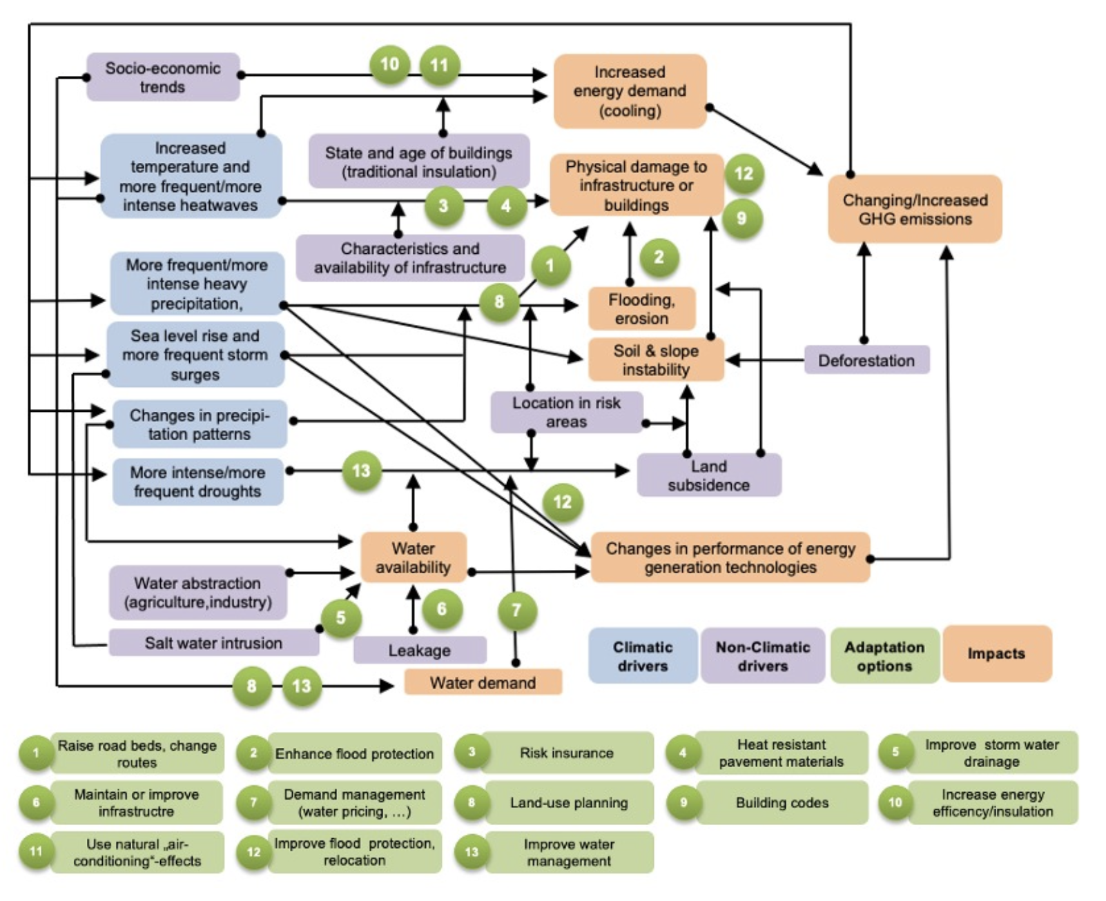
Currently urban areas have to face many challenges. Overall, urbanization, demographic change, digitalization and climate change are main drivers that may directly or indirectly have an impact on the lifestyle and well-being of city dwellers. All drivers are interconnected and together with other sector-relevant drivers they form a complex network, that is difficult to understand at first glance, and has many points of friction between different interests.
For example, a growing urban population needs more space for housing areas. Due the increase of sealed spaces, impacts of climate change or negative effects on the water cycle are rising. Less groundwater recharge and a higher water demand lead to decreasing groundwater levels in conjunction with land subsidence that can cause damages at buildings and infrastructure.
Such scenario, evidenced by countless examples, is causing city governments to think about how to manage the water in and under the city – especially while taking into account changing climatic conditions. The brief insight in a complex system built by different sectors, players and drivers (Fig. 1) illustrates that a) there are neither simple questions nor simple answers, b) any intervention can lead to positive and negative outcomes, and c) tools are needed to simulate these non-linear changes in the system in order to be able to proactively meet current and emerging challenges.
Smart city and digital twins
In recent years, a trend towards “smart cities” can be seen as the velocity of data collection has increased. One goal here is the intelligent connection of municipal infrastructure to make city administrations more efficient in improving the quality of life for residents. The idea of the progressing digitalization is to transfer parts of the real word into virtual representatives. Some are referred to as digital twins (Sharma et al. 2022).
Digital twins have been found useful in manufacturing, construction, and maintenance. In contrast, a holistic digital twin of a city would have to cover many fields of action, including
all associated technical and human interfaces. For this, extensive data collections and a better systemic understanding of linkages and feedback loops are necessary in advance. As a result, the final product would provide city administrations with a powerful tool. Positive first approaches of such digital twins can be found for the cities of Helsinki (Ruohomäki et al. 2018), Zurich (Schrotter & Hürzeler 2020) and Vienna (Lehner & Dorffner 2020). (Links: Ruohomäki et al. 2018: doi: 10.1109/IS.2018.8710517, Schrotter & Hürzeler 2020: doi.org/10.1007/s41064- 020-00092-2, Lehner & Dorffner 2020: doi. org/10.1007/s41064-020-00101-4).
However, these digital twins differ in their technical structure and target for which they were developed. Typically, they are used to control critical infrastructure sectors. In the following it will be shown that another area of application is the management of urban flood protection.
The changing urban water cycle
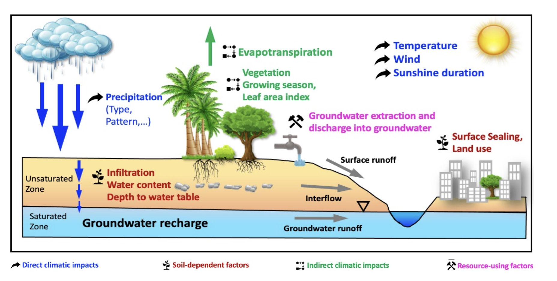
The urban water cycle is influenced by structures, lifestyles and new recreational behaviour, but also increasingly by climate change impacts (Fig.2). All of its components experience direct or indirect changes. Due to climate change, temperatures are rising, increasing the water demand and also raise evaporation rates. Both factors influence the groundwater resources. In addition, in many places summer becomes drier, while more precipitation falls in winter times. The number and intensity of heavy rain events increase and dry periods are becoming longer.
On the supply side, higher demand peaks in summer already pose greater challenges to water suppliers. Heavy rainfall can flood parts of the infrastructure or cause power failures, whereas both can lead to restrictions in the water supply. To put it in a nutshell climate change impacts will influence the temporal and overall availability of water (Bender et al. 2021).
Climate parameters raise questions, digital twins can answer them
To react proactively to future extreme weather events, many city administrations currently use hydrological or urban climatological models (one form of digital twins). By simulating different weather scenarios, decision-makers get an idea which potential impact can occur and which adaptation measures promise the greatest overall success. For this, regional climate projections provide a possible view, what and how many challenges can be expected in the future. Examples of this are the GERICS Climate Outlook documents for German administrative districts (cf. Rechid et al. 2021).
With their help, users get an overview of how temperatures will change or how often heavy rainfall can be expected. But what do these changes mean for future challenges in the urban area? Possible answers can be found when using a digital twin. To demonstrate that this is possible for all municipalities, GERICS initiated a joint prototypical project with a small municipality close to the river Elbe (Groth et al. 2020, GERICS Report 34).
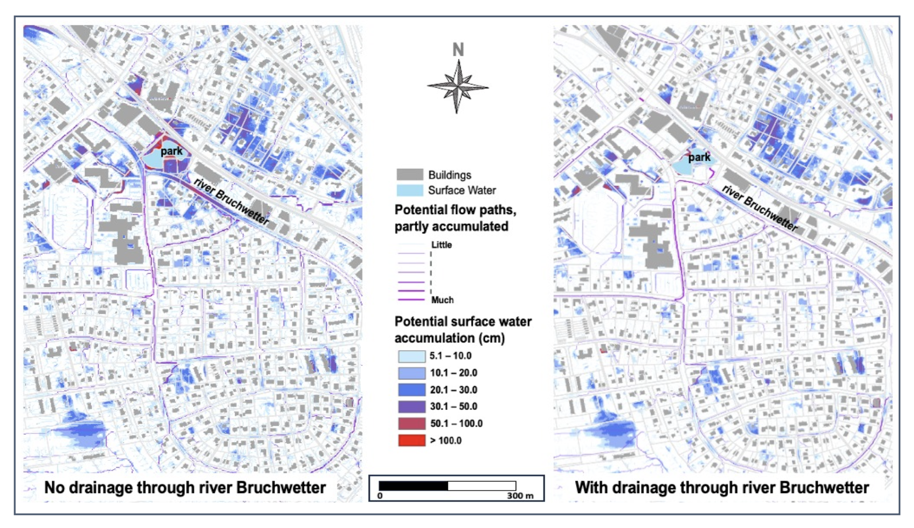
Even though the municipality is well versed in river flooding, there are clear deficits in terms of urban flooding after heavy rain events, which have already occurred in the past. In order to get an idea of the potential future flood situation, a model was used to simulate the runoff of an extreme heavy rainfall event (60 mm in one hour). Potential hot-spots were located, which had already caused problems in the past. The digital twin, however, highlighted the special importance of the river “Bruchwetter”, which drains the entire area. In order to sensitize the city about the importance of the drainage functionality, two scenarios were simulated with: a) a blocked, and b) a well-permeable drainage ditch. The results show that water accumulates in front of obstacles, which significantly worsen local flood situations (Fig. 3).
However, the maps also show that some residential areas will be flooded even if the “Bruchwetter” drains properly. Here, further adaptation measures are recommended. All these results generated by the digital twin show, that a good overview of possible impacts and mechanisms is possible with relatively little effort.
Anticipatory flood protection through digital urban planning
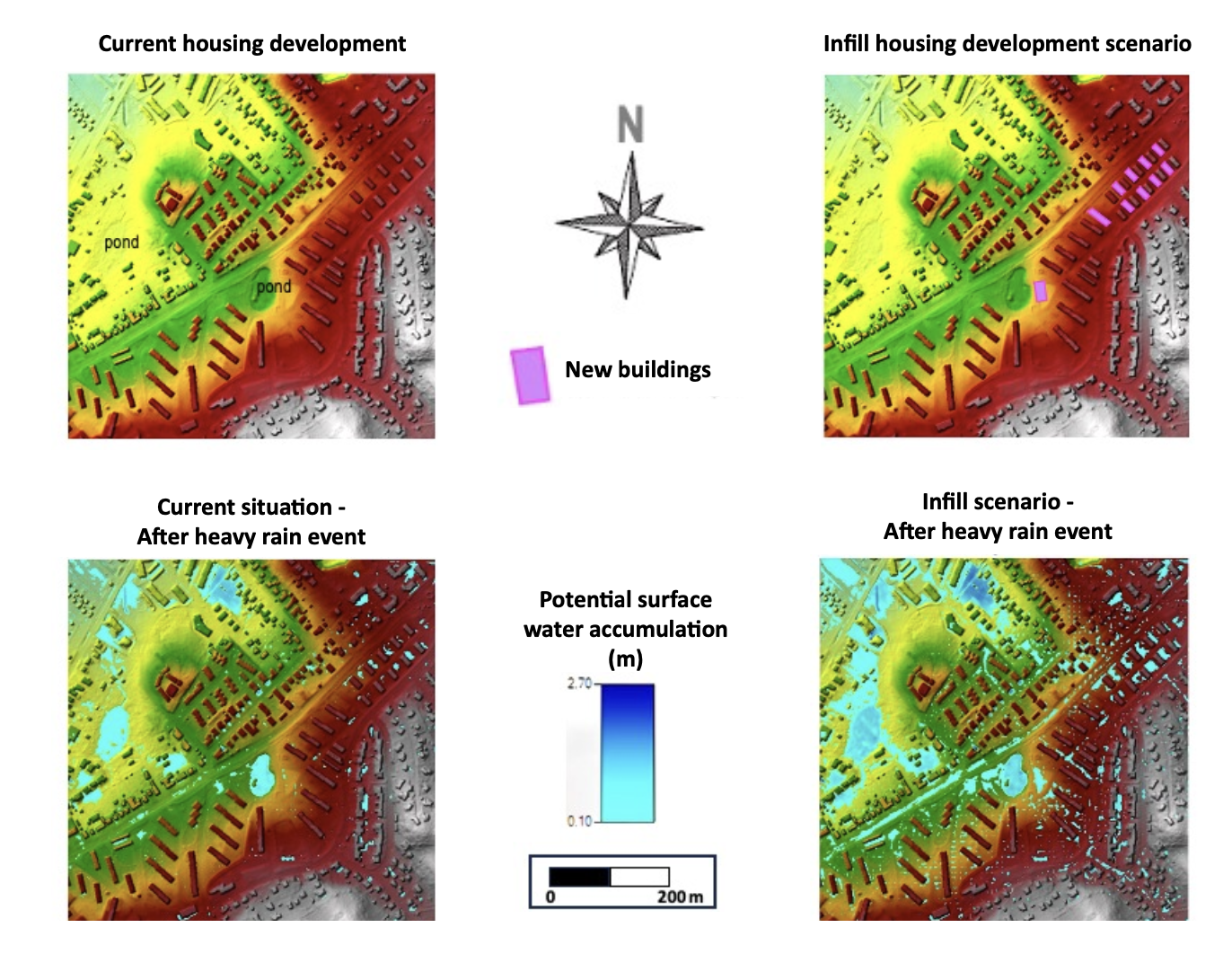
Since the catastrophic floods in July 2021 in Germany, many German city administrations have been asking themselves: what could be the impacts of such an event for my municipality? Since cities are subject to constant change – with regard to land use, building developments or climatic boundary conditions – digital twins are also a helpful tool to answer this question. They can be used to expose todays or future urban structures to current and future climatic conditions. In cooperation with parts of the administration of the City of Geesthacht, GERICS investigated in the context of a pilot project, (Bender et al. 2023, City Series 04), whether the freely available rainfall-runoff model HEC-RAS (U.S. Army Corp of Engineers) can answer the following central questions for current and future climate conditions:
- a) Which areas are potential floodplains after heavy rainfall?
- b) What are the effects of a densification development on potential flooding?
To do this, we used scenarios that reflect the different framework conditions. Some selected results are shown in Fig.4.
In the current construction situation, a heavy rain event initially causes surface flow paths, moving water towards the two ponds and out of the model area. However, parts in a residential area to the north are also flooded. The installation of further buildings locally increases surface sealings and thus surface runoff. In combination with the larger amounts of water at the extreme heavy rainfall event, surface water in the model increases.
This is reflected by higher water depths in accumulation areas. In the vicinity of the new buildings the effects are only small. In contrast, the flood risk in the adjacent area to the north and downstream has increased significantly. In general, the results of the scenario assessment showed that even extreme heavy rainfall events lead to few local floods in housings areas, only. To sum up, with a digital twin, it is possible to simulate effects of planned construction measures in advance. For each scenario city planners get an idea of potential hot-spots where water could flood for example basements or low- lying garages.
Digital twin for critical infrastructure protection
But not only municipalities use digital twins to prepare for current and future challenges. Increasingly, companies such as critical infrastructure operators are also making use of them, as they are more and more affected by impacts of weather extremes (Groth et al. 2022). For example, flooded roads and railway tracks after heavy rain events can lead to outages or impairments in the transport and traffic sector. Although all components of transport infrastructure are designed to withstand a certain degree of weather-related stress, climate change is shifting the technical requirements. Thus, companies must proactively prepare for the new challenges to ensure trouble-free operation.
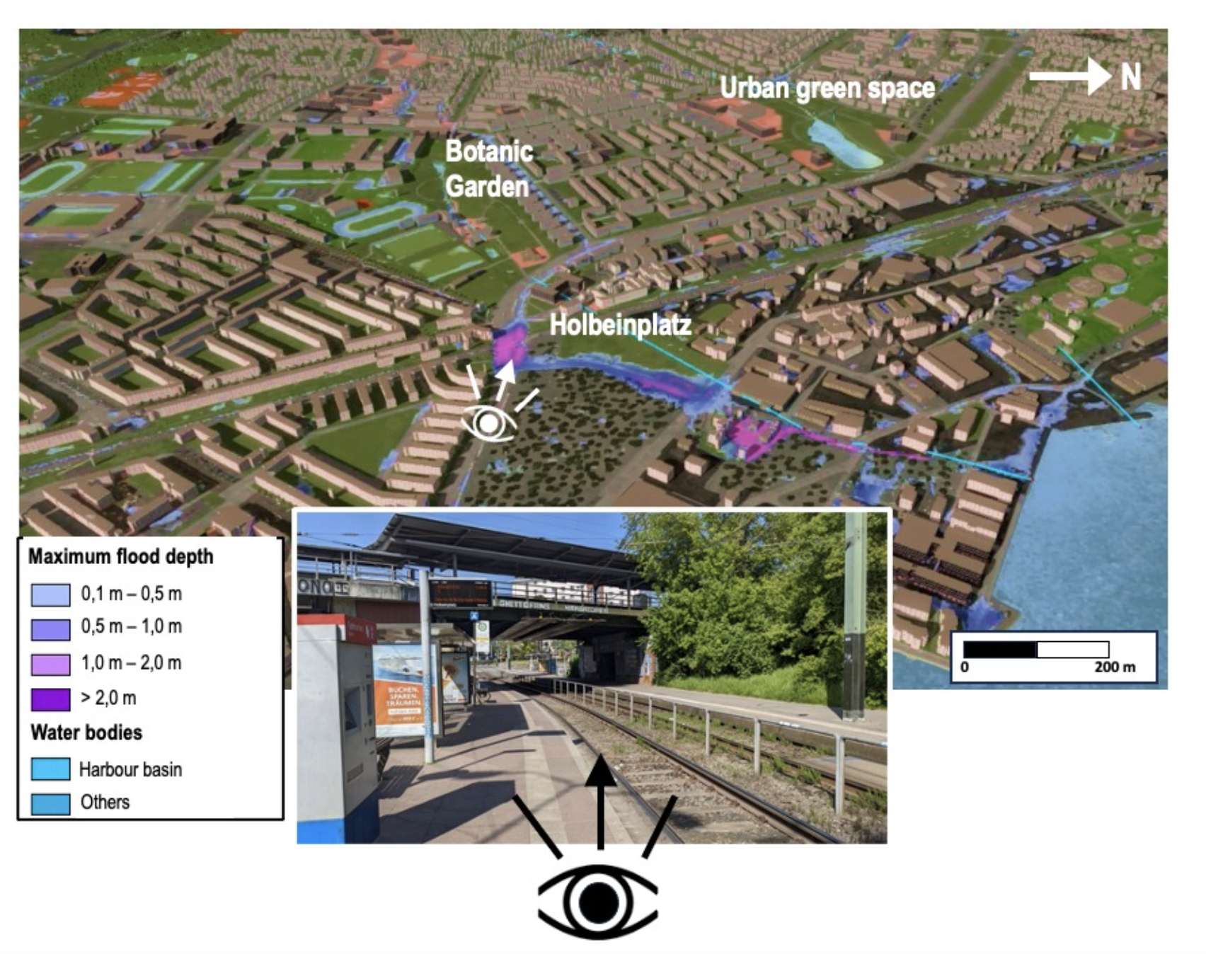
Within the framework of a prototypical product development, GERICS examined together with an urban transport service climate impacts on the day-to-day transport business. The aim was to sensitize the employees to the problem and to integrate the idea of adapting climate impacts into internal processes. One component of this approach was to use a digital twin to visualize selected challenges. The area around the company’s site up to an important traffic junction was selected as a focal point. The recognition value of the employees to the model was increased by using a simplified 3D model (Fig. 5).
In order to clarify detailed questions, we used another small-area digital twin with higher resolution data. This model confirms the location as being a hot-spot for flooding, the natural depressions at Holbeinplatz and its north- western extension towards the harbour area. Since it is difficult to bypass the area, further work focused on improving the early flood warning system in order to prevent damages as much as possible. Structural adaptation measures are currently not being discussed.