
Shashin Mishra, Vice-President of EMEA at AiDash, examines how monitoring ecosystems from space can revolutionise biodiversity net gain progress and aid the eco-crisis
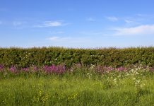
The global crisis of rapidly declining biodiversity has risen to greater public awareness in recent years. Studies warning of the sixth mass extinction of life on Earth, and that species are dying off 1,000 times more quickly than before the arrival of humans 60 million years ago have prompted action on the international stage.
Most notably, COP15 oversaw the introduction of the Global Biodiversity Framework, which aims to conserve and restore 30% of the world’s land and oceans by 2030. (1)
The biodiversity crisis
The consequences of biodiversity loss are severe. Biological diversification is essential to the resilience of ecosystems which perform vital functions such as climate regulation, flood control, and pollination. It is also increasingly recognised as a business concern and was ranked as the third highest risk to business in the World Economic Forum’s 2022 Global Risks Report. (2)
The UK is understood to be the most biodiversity-depleted country in the world. In response, the Government has passed the Environment Act into law to drive Biodiversity Net Gain, targeting goals such as ensuring “that species abundance in 2042 is greater than in 2022, and at least 10% greater than 2030”. (3)
Challenges holding back biodiversity net gain
Despite the urgency of the crisis, only 3% of UK businesses say that they monitor nature or biodiversity-related risks, according to a recent Office for National Statistics study. (4) This figure stands in contrast to the stated aims of chief sustainability officers (CSOs) in businesses around the world. In a global survey of over 500 CSOs, 24% told AiDash that they currently include biodiversity impact in their sustainability strategies, and 66% said they already have a role dedicated to biodiversity.
So, while there is certainly room for businesses to do more to effect positive change in restoring ecosystems for biodiversity net gain, having the right tools to do so is just as much the problem, if not more so, than a lack of desire to act.
Nowhere is this challenge more glaring than in land planning, where the Environment Act mandates that 10% biodiversity net gain must be achieved for all development projects in England and comes into effect this November.
When the local planning authorities (LPAs) – who are responsible for ensuring this – spoke to Defra, 90% of them revealed that their current expertise and ecological resources would be inadequate to deliver biodiversity net gain, and just 5% believed they had what they needed to scrutinise all applications that might affect biodiversity thoroughly. (5)
Over the last decade, the supply of qualified ecologists has consistently decreased while the demand for qualified ecologists to monitor ecosystems has consistently increased. There is no quick fix to this issue as it takes years to train ecologists to the point where they can measure ecosystems and test biodiversity impact to the level required for LPAs to carry out their duties or for businesses to put strategies in place that they can report on.
The solution to the biodiversity crisis from space
One of the critical steps in preserving ecosystems and working towards biodiversity net gain is working out the baseline of the land biodiversity for the area in question. Without this, it is difficult for landholders and authorities to calculate what they need to do to meet their targets. The task of baselining sites is extensive and relies upon making ecological surveys more efficient.
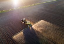
With time being of the essence, and in the absence of a deep pool of ecologists to deploy on the ground, a solution is waiting to be used in space. Technological advances allow businesses to automate ecological surveys by taking advantage of satellite imagery and cutting-edge AI models.
Traditional ecological surveys are highly manual and complex, requiring a team of ecologists to be dispatched to a site – often for weeks on end – to collect data from key sample areas and, from this, deduce the overall data for the entire space that is being monitored. Inevitably, these measurements suffer from incompleteness and unconscious bias and, in addition to this, they are expensive to obtain across larger areas or distributed estates.
By contrast, satellites can quickly cover 1,000s of sites, and AI models can analyse them in mere weeks to accurately measure biodiversity in a given ecosystem and provide insight into how biodiversity net gain might be achieved in this ecosystem. Crucially for the users of this technology, it also works out as a cheaper way of managing biodiversity operations.
Satellite technology promises to revolutionise the current biodiversity net gain methods
Legislation around biodiversity impact and what strategies businesses employ to address it will only become stricter. As LPAs struggle with rapidly declining deadlines and a massive shortage of skills in ecology, adopting satellite technology is the only way they can meet looming biodiversity net gain mandates.
More broadly, businesses with large corporate land holdings, such as utilities or agriculture companies, also have a crucial role to play in improving and protecting biodiversity. Utility providers control over 450,000 acres across the UK. By using satellite technology – they can unlock the potential of their land quickly and effectively.
The key to enabling different parties to play their part lies in streamlining and simplifying the process of monitoring ecosystems. Satellite technology promises to revolutionise the current methods used for biodiversity net gain progress.
References
- https://www.un.org/sustainabledevelopment/blog/2022/12/press-release-nations-adopt-four-goals-23-targets-for-2030-in-landmark-un-biodiversity-agreement/
- https://www.weforum.org/reports/global-risks-report-2022/
- https://cardinalenvironment.wordpress.com/2022/12/16/environmental-targets-uk/
- https://www.ons.gov.uk/businessindustryandtrade/business/activitysizeandlocation/articles/natureandbiodiversityrisksmonitoredby3ofukbusinessesaheadofcop15/2022-12-06
- https://randd.defra.gov.uk/ProjectDetails?ProjectID=20638&FromSearch=Y&Publisher=1&SearchText=NR0183&SortString=ProjectCode&SortOrder=Asc&Paging=10
Contributor Details

Editor's Recommended Articles
-
 Must Read >> Biodiversity in crop & soil health management
 -
-